Image map created for AFORR by OR KM Web Design using map from Tennessee Division of Natural Heritage.
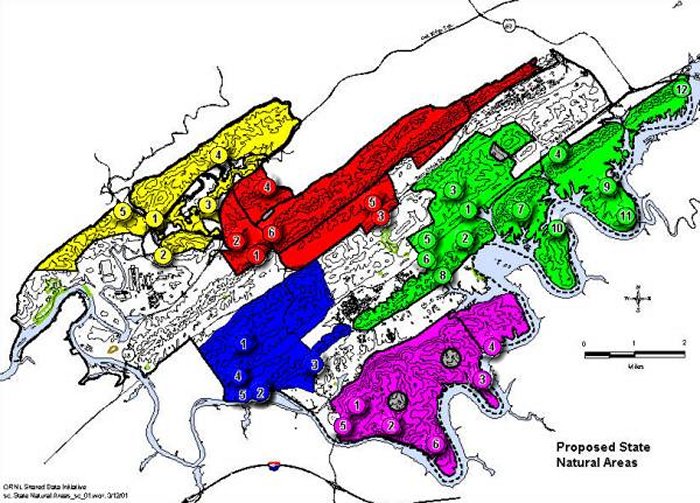
After considering new information, the Division of Natural Heritage concluded that the ecological significance of the ORR warrants additional protection under state law (T.C.A. 11-114-108). Hence, the agency identified five natural area subunits that contain 30 ecological sites (mapped below) and that comprise approximately 20,000 acres of the ORR. According to TDEC, these five natural area subunits represent the most contiguous ecological core areas that can be preserved at a landscape level at ORR. TDEC notes that the ORR contains many other relatively small disjunct areas that are not included within the proposed ORR DSNA. These are areas that contain isolated, rare species and/or significant species assemblages and deserve special consideration for protection as State Botanical or Zoological Sites.
According to TDEC, the new proposal for the ORR DSNA "carefully and intentionally excludes areas of the ORR that are currently developed, or planned for development." Thus, valuable areas preliminarily identified by DOE for transfer to developers may have been excluded.
The proposed designation is intended to allow DOE and the State the ability to collaborate on significant natural resource initiatives, including research, restoration, and monitoring, within the five natural area subunits. Specific initiatives may include barrens restoration, establishment of warm season grass production fields for use in ecological restoration, and collaboration in the control and management of invasive species. This last objective is identified as a priority on federal lands under Executive Order 13112.
Click on a numbered site to read a discussion of the indicated area in another window. Switch back to this window to see the map again.
Image map created for AFORR by OR KM Web Design using map from Tennessee Division of Natural Heritage.